

North Point State Park is located just north of Baltimore via the Key Bridge ($4 each way). After crossing Baltimore Harbor you will encounter an amazing sight. On the east side of the Patapsco River where the historic Bethlehem Steel and Sparrows Point steel mills once stood with their surreal and slightly forbidding black smelting ovens that produced vast quantities of steel for generations, is now a modern mega-distribution site called Tradepoint Atlantic, employing thousands of workers. Basically, a lot of what arrives by ship into Baltimore these days ends up getting processed and then moved by truck from this new commercial port of entry along Bethlehem Boulevard. Acres and acres of new cars sit waiting to be shipped to car dealerships all over the east coast. The complex stretches as far as the eye can see with huge, one-to-four story big box warehouses bearing hotshot names like Under Armour, FedEx, Amazon Fulfillment Center, Access World, Alcoa World, Atlantic Forest Product Warehouse, and Harley Davidson. And from the looks of it, there’s way more coming.


You often hear about how the Baltimore area doesn’t have its act together, but in this case they turned a contaminated industrial dead zone into a vibrant money machine in about a year. Presto-changeo! Out with the old and in with the new.


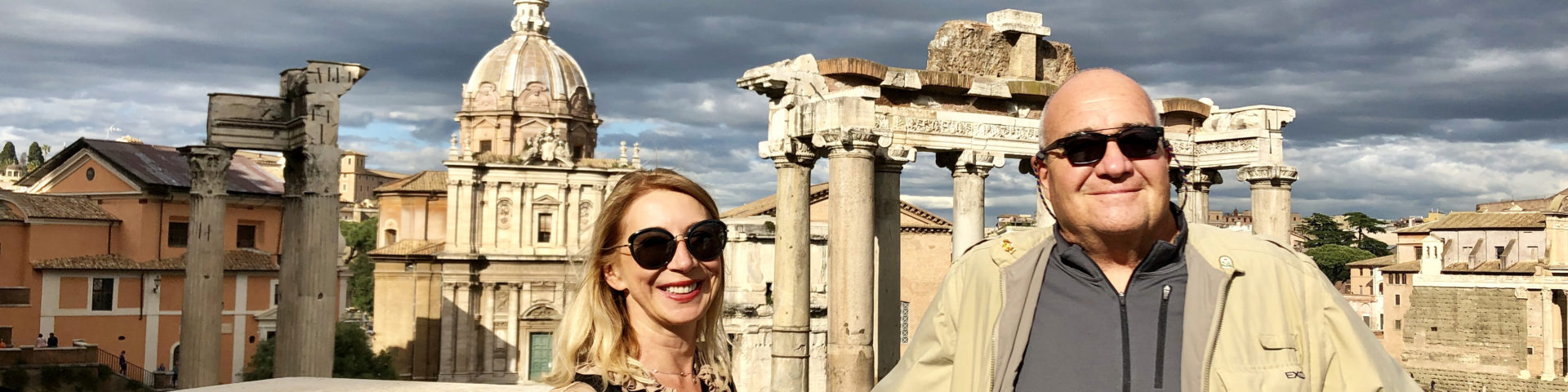
After passing through the small, blue collar town of Edgemere, you will come to North Point State Park, located on the Patapsco River Neck Peninsula. Its rich alluvial farmland at the edge of the Chesapeake Bay has made it a popular place to live, going back 9,000 years to the Indians who lived along its shores.

It was also the site where the War of 1812 miraculously turned against the British. We are all familiar with the shelling of Fort McHenry and a desperate Francis Scott Key penning the “Star Spangled Banner” in the dawn’s early light. But what gets lost in the rockets red glare is the fact that on September 12,1814, as part of the siege of Baltimore, British General Robert Ross was leading his troops on an end run flanking maneuver to capture and burn Baltimore when he was killed by a sniper hiding in the second floor of a farmhouse called Todd’s Inheritance, and this so confused and demoralized the British forces that they ended up ultimately abandoning their attack on Charm City. This was the turning point of the war which up until then had seen the British burn Washington and win every battle along the way.


And that’s not all. From 1906-1947, North Point was the home of the sprawling Bay Shore Amusement Park, built by the United Railways and Electric Company of Baltimore. A trolley/streetcar line and large steamboats delivered the citizens of Baltimore to the park where they could enjoy a day of leisure along the Bay and dine luxuriously on white table cloths, eating crab cake and fried chicken full course meals for 75 cents.

In 1947, Bethlehem Steel purchased the land and knocked down the amusement park. And in 1987, the Maryland Department of Natural Resources (MDNR) purchased the land from Bethlehem Steel for five million dollars and created what was originally called Black Marsh State Park.

So, if you want to walk back through Maryland history, North Point State Park is a good place to start.

My buddy Jimmy and I started our 5-mile loop hike on the Black Marsh Trail (White) which begins in the big parking lot on the left just after the entrance station.

White egrets perched in the dead trees of the expansive marsh as green, little blue, and great blue herons fished in the shallows. Eastern Peewees were singing “Pee-Wee!” non-stop (they have been in every state park we have visited over the summer), and woodpeckers hungrily banged their heads against trees. Black swallowtail butterflies fluttered daintily around the dirt path, looking for nectar while bald eagles sat majestically in the solitary sentinel trees throughout the swampy creek that was teeming with water snakes and big, bass drum frogs.

We turned left on the Observation Trail (Blue) along the spongy wet edge of the marsh. One lone photographer snapping bird shots was the only person we would see for the next few hours.

Large tulip poplars and oaks ended at a raised wooden observation deck surrounded by phragmites wetlands grass that completely blocked the marshy view. There is much debate these days as to whether “phrag“, as it is often referred to, is an invasive or whether it predates European settlement. Whatever the case, it sure loves the shorelines of the Chesapeake Bay.

Black Marsh totally reminded me of the Florida Everglades, but without the swarming mosquitoes.

We retraced our steps to the Black Marsh Trail and after a few hundred feet took the Muskrat Trail (Yellow) where we were serenaded by the prehistoric screams of herons and snowy egrets accompanied by a crazy cicada chorus from the treetops. This short path ended at another marsh where there was probably another nice view of the water, but, once again, all we could see was a wall of twelve-feet-tall phragmites.

We then took the Holly Trail (Red) for a quarter mile before turning left on the Powerhouse Trail spur that ended at a driftwood trash pile on the Bay. From here on, the trails would parallel the park’s bay front shoreline, heading south.

We walked back the way we had come on the Powerhouse Trail for a quarter-mile and then took the Spur Trail (Green) to a lovely beach facing Tolchester on the upper Eastern Shore, just north of the forgotten town of Gratitude and up and coming Rock Hall where the Tolchester Amusement Park — Bay Shore’s sister park across the Bay — used to stand in the early 1900s.

After lounging on a bleached driftwood log for about an hour, just chatting and staring at the silvery Bay as the occasional tanker made it’s way north to Delaware Bay via the Chesapeake & Delaware Canal, we resumed our hike, following the Powerhouse Trail past the ruins of the huge, vine draped and graffiti-covered powerhouse.


After a half-mile or so we rejoined the Black Marsh Trail with several short spurs branching off to the left and leading to small secluded beaches. There were shiny white fish scales on the path where the local eagles had recently dined.

The one thing we didn’t see was deer. The park has a very aggressive managed deer hunt — mostly bow hunters — that has kept the deer population in check.

We soon took a left on the Ferry Grove Trail (Blue) to the crumbling concrete ferry boat dock which offered a stellar, wide-angle view up and down the Bay. This was where park visitors landed by boat when the amusement park was in full swing. Time has not been kind to the structure. Jimmy and I sat on the shattered stone pier and tried to imagine hordes of Baltimorons gaily disembarking for a day at the beach way back in the day. It must have once been a happening spot indeed.

A few minutes later we took a left on the Old Oak Trail (Turquoise) past the ruins of water cisterns and brick foundations associated with the Bay Shore Amusement Park.

We then experienced one of the unique aspects of Maryland’s natural landscape. The elevation dropped a few feet and suddenly we went from poplars and pine trees to nothing but hollies — some of the biggest I have ever seen — along with a 2-foot diameter persimmon tree. And that’s pretty big for that species.


After about a mile we turned right on the Beaver Pond Trail (Red) which led us back to the entrance road.

We turned left and walked up the asphalt road to the main beach where we encountered people for the first time since starting our hike about three hours before. Most of our state parks are empty and used primarily by people of color. In fact, many of the informational signs are in English and Spanish.

The area around the beach at North Point is where most people go. And there are plenty of interesting amenities scattered around the beach, like the Takos Visitor Center, resembling the historic dining lodge, and a lovely ornamental fountain from the park’s heyday as an amusement park; several picnic areas adorned with the original United Railways and Electric Company trolley station, lovingly restored by DNR staff and now functioning as an outdoor pavilion; and a brand new stone fishing jetty, jutting a thousand feet out into the Bay.


After checking out the local fishermen at the end of the jetty who were catching white perch and spot, Jimmy and I decided to head back to our car, following the main entrance road. There was an afternoon storm rolling in and we were tired. But while we had seen most of the main attractions in the park, we had only walked about half the trails, and had not visited Todd’s Inheritance where the War of 1812 went south for the British.

On the mile-long walk back to the car, we passed lush soybean fields which the Maryland Department of Natural Resources rents to local farmers, carrying on the agricultural traditions of the North Point peninsula. “Want to see something cool?” I asked my hiking partner.
“Sure,” replied Jimmy with a tired smile.
We walked out into the field, being careful not to step on the dark green soybean plants that were up to our knees, and stopped when we came to a low lying open area where sediment had collected. I looked around the sandy spot for a few minutes until I spotted what I was looking for and I pointed at a dark piece of black stone about the size of a silver dollar.

“What is it?” asked Jimmy.
“Don’t touch it,” I warned, “this is technically an archaeological site. And that’s a piece of basalt — volcanic rock — that was mined in western Pennsylvania near Pittsburgh. This is the coastal plain and you would have to go hundreds of miles to the west before you’d find obsidian like that. The Indians who lived on this peninsula thousands of years ago traded for it, so they could make spear points. This shows that not only were Indians inhabiting this area long ago, but that they had also established a pretty extensive trading network.”

Jimmy looked at the stone in wonder. “This park is amazing!” he exclaimed.
“They all are, my friend. People just have to take the time to check them out.”


cost lasuna – buy lasuna generic himcolin for sale online
buy lasuna online – order himcolin without prescription how to get himcolin without a prescription
how to buy besivance – purchase sildamax pills purchase sildamax generic
buy gabapentin 600mg sale – azulfidine 500 mg ca buy sulfasalazine 500 mg online cheap
cost besivance – purchase besifloxacin sale sildamax canada
neurontin 600mg ca – ibuprofen ca purchase sulfasalazine pills
probenecid 500mg pills – order carbamazepine 200mg without prescription tegretol for sale online
buy celebrex 100mg generic – purchase flavoxate buy indomethacin 50mg sale
benemid 500mg for sale – cheap monograph 600mg order tegretol 200mg pill
order mebeverine 135 mg pills – etoricoxib 120mg usa order pletal
brand celecoxib – buy indomethacin 75mg without prescription indomethacin for sale online
buy voltaren 100mg sale – aspirin order aspirin 75mg over the counter
purchase colospa generic – order colospa without prescription buy pletal medication
buy cambia pills for sale – aspirin uk buy aspirin without prescription
buy generic pyridostigmine 60 mg – buy imuran 50mg buy imuran generic
mestinon for sale online – sumatriptan 25mg cost where can i buy azathioprine
バイアグラの購入 – г‚їгѓЂгѓ©гѓ•г‚Јгѓ« – 50mg/100mg г‚·г‚ўгѓЄг‚№ е‰ЇдЅњз”Ё
purchase domperidone generic – brand domperidone buy cyclobenzaprine medication
cheap motilium 10mg – domperidone uk cyclobenzaprine 15mg canada
purchase inderal pill – methotrexate oral methotrexate medication
buy propranolol online cheap – buy propranolol generic order methotrexate 2.5mg
warfarin uk – buy generic hyzaar buy losartan 50mg for sale
cheap esomeprazole – buy generic sumatriptan over the counter buy generic sumatriptan
esomeprazole 20mg over the counter – buy topamax 100mg without prescription imitrex brand
levofloxacin 500mg uk – buy generic zantac 150mg buy ranitidine
order meloxicam 7.5mg without prescription – order mobic 7.5mg pill buy tamsulosin 0.2mg generic
meloxicam price – celebrex 200mg tablet buy tamsulosin 0.2mg generic
zofran 4mg cost – order zocor pills order simvastatin 10mg sale
order valacyclovir 500mg without prescription – order generic valtrex brand fluconazole
buy zofran – buy aldactone 100mg generic order zocor
buy valtrex sale – valtrex 1000mg without prescription buy diflucan without a prescription
modafinil 100mg us buy modafinil medication buy cheap modafinil modafinil 200mg usa modafinil sale provigil 200mg ca provigil 200mg brand
buy generic modafinil 200mg order provigil without prescription modafinil pill buy generic modafinil purchase modafinil pills buy provigil without a prescription modafinil 200mg pills
I couldn’t hold back commenting. Warmly written!
This is a keynote which is in to my callousness… Numberless thanks! Faithfully where can I upon the connection details in the course of questions?
I am in truth thrilled to glitter at this blog posts which consists of tons of profitable facts, thanks object of providing such data.
The sagacity in this serving is exceptional.
zithromax tablet – order metronidazole 400mg generic buy metronidazole 400mg pill
zithromax 500mg without prescription – tindamax 300mg generic metronidazole ca
buy semaglutide generic – generic semaglutide 14 mg buy cyproheptadine 4 mg generic
rybelsus 14 mg canada – cyproheptadine 4 mg over the counter purchase periactin online cheap
order domperidone online – buy generic motilium over the counter cyclobenzaprine oral
motilium 10mg sale – purchase motilium generic order generic flexeril 15mg
inderal price – buy inderal 20mg pills buy methotrexate 2.5mg for sale
purchase amoxicillin sale – buy generic amoxicillin combivent 100mcg cheap
amoxil without prescription – order ipratropium 100 mcg pill combivent cheap
azithromycin over the counter – oral nebivolol nebivolol 5mg pills
buy zithromax cheap – brand nebivolol 5mg buy bystolic paypal
buy generic clavulanate online – at bio info ampicillin usa
buy augmentin for sale – atbioinfo.com ampicillin for sale
buy esomeprazole generic – anexamate.com order esomeprazole generic
nexium 20mg pills – nexium to us esomeprazole 20mg cheap
how to get warfarin without a prescription – https://coumamide.com/ buy losartan 25mg sale
generic medex – https://coumamide.com/ losartan 50mg pills
order meloxicam 7.5mg for sale – swelling meloxicam 7.5mg generic
mobic online buy – tenderness order meloxicam 15mg online
online ed meds – best place to buy ed pills online buying ed pills online
ed pills cheap – fastedtotake.com how to buy ed pills
cheap amoxil without prescription – combamoxi.com amoxicillin without prescription
order amoxil generic – amoxicillin brand buy amoxicillin
diflucan uk – click order diflucan 100mg pill
purchase forcan pills – https://gpdifluca.com/# diflucan 100mg cost
oral escitalopram – escita pro lexapro over the counter
cenforce oral – https://cenforcers.com/ order cenforce online
cenforce generic – buy cenforce pills for sale cenforce oral
best place to buy liquid tadalafil – https://ciltadgn.com/ does cialis make you harder
cialis canada over the counter – https://ciltadgn.com/ does tadalafil work
zantac 300mg pills – zantac 300mg price purchase ranitidine generic
buy zantac 150mg pill – click zantac price
where can i buy cialis on line – click cialis buy online canada
mail order viagra legitimate – https://strongvpls.com/# order viagra india online
This is the kind of delivery I turn up helpful. site
viagra buy greece – on this site viagra online discount
More articles like this would make the blogosphere richer. this
I’ll certainly carry back to be familiar with more. neurontin where to buy
This is the stripe of serenity I take advantage of reading. https://ursxdol.com/sildenafil-50-mg-in/
The thoroughness in this break down is noteworthy. https://buyfastonl.com/furosemide.html
This is the type of delivery I unearth helpful. https://ursxdol.com/amoxicillin-antibiotic/
This is the stripe of topic I enjoy reading. https://prohnrg.com/product/omeprazole-20-mg/
With thanks. Loads of expertise! https://prohnrg.com/
This is the amicable of topic I take advantage of reading. https://aranitidine.com/fr/acheter-cialis-5mg/
More posts like this would bring about the blogosphere more useful. https://aranitidine.com/fr/ciagra-professional-20-mg/
I’ll certainly bring to be familiar with more. https://ondactone.com/spironolactone/
This is a keynote which is virtually to my fundamentals… Myriad thanks! Faithfully where can I upon the contact details due to the fact that questions? https://ondactone.com/spironolactone/
More content pieces like this would insinuate the web better.
https://doxycyclinege.com/pro/sumatriptan/
More posts like this would create the online time more useful.
can you get tetracycline without prescription
I couldn’t resist commenting. Warmly written! http://www.fujiapuerbbs.com/home.php?mod=space&uid=3616671
This is the kind of delivery I find helpful. http://www.orlandogamers.org/forum/member.php?action=profile&uid=29103
forxiga medication – janozin.com buy dapagliflozin pills
dapagliflozin pill – https://janozin.com/# buy dapagliflozin 10mg online
purchase orlistat online cheap – https://asacostat.com/# xenical where to buy
This is a topic which is virtually to my verve… Many thanks! Unerringly where can I upon the acquaintance details for questions? http://www.underworldralinwood.ca/forums/member.php?action=profile&uid=493433
I am in truth enchant‚e ‘ to gleam at this blog posts which consists of tons of of use facts, thanks for providing such data. http://www.orlandogamers.org/forum/member.php?action=profile&uid=29920
You can shelter yourself and your family close being alert when buying pharmaceutical online. Some pharmacopoeia websites control legally and offer convenience, solitariness, rate savings and safeguards for purchasing medicines. buy in TerbinaPharmacy https://terbinafines.com/product/sildalis.html sildalis
You can conserve yourself and your dearest close being heedful when buying pharmaceutical online. Some druggist’s websites control legally and put forward convenience, secretiveness, bring in savings and safeguards as a replacement for purchasing medicines. buy in TerbinaPharmacy https://terbinafines.com/product/medrol.html medrol
This is the compassionate of literature I truly appreciate. TerbinaPharmacy
This is a question which is near to my verve… Numberless thanks! Unerringly where can I find the phone details in the course of questions? TerbinaPharmacy
This is a question which is in to my fundamentals… Numberless thanks! Faithfully where can I notice the connection details for questions?
More articles like this would pretence of the blogosphere richer.
best online casino for real money
best casino online
fourth slot in a baseball lineup
betmgm Colorado betmgm-play betmgm GA
betmgm NC betmgm Florida mgm 200 free bet
Step into the world of endless possibilities. In crown coins casino, there’s everything for your gambling leisure. Register and get a gift!
Feel the taste of luxury in online games. crowns coins offers high-quality slots and bonuses. Win more than you expected!
Experience the ultimate candy adventure in Sweet Bonanza, where wins pay anywhere on the grid! Bomb sweet bonanza free spins multipliers can turn small bets into life-changing hauls. Join the fun right now!
Get lost in the delicious world of Sweet Bonanza, where every match explodes into more wins! Ante sweet bonanza casino bet boosts your chances, bonus buy delivers instant action. Sweet riches are just a spin away!
chicken game offers non-stop excitement: bet, cross, multiply, cash out! Four difficulty levels suit every risk appetite. Get hooked on the ultimate crossing challenge!
Push the limits in difficulty levels — how far can your chicken go? Cash out decisions deliver massive rewards when timed right. 98% RTP keeps it fair and fun!
Experience the raw power of the American wilderness in slot form. buffalo slots real money packs wild symbols, scatter sunsets, and retriggering free games for unbeatable action. Join the rush and win big!
Dive into the iconic world of prairie power and fortune. buffalo slots brings Aristocrat’s masterpiece with free spins galore, multipliers up to 27x, and progressive prizes. Your jackpot journey starts here!
No deposit, no problem — chumba casino promo code gives you free Sweeps Coins to start winning. Enjoy top-tier games and real cash prize potential. Sign up free!
luckyland slots app: The social casino that pays out! Get started with 7,777 free Gold Coins and 10 Sweeps Coins today. Play premium games and redeem Sweeps for real money!
Chumba Casino — more wins, more fun, zero purchase required. Get your free chumba casino no deposit bonus today and spin the reels on top games. Real rewards await!
DraftKings casino promo Casino: Thrills without the risk. New users score 500 spins after $5 + up to $1,000 lossback protection. Discover why players choose us!
Best slots on DraftKings Casino delivers premium play. Unlock 500 Cash Eruption spins with a $5 bet plus up to $1,000 back if needed. From jackpots to live tables—it’s yours!
betmgm casino review Casino — where legends play and winners stay. Sign up for 100% deposit match up to $1,000 plus $25 free play. The thrill never stops.
La sante est un droit, la rendre accessible est notre mission. Nous vous offrons le meilleur de la pharmacie sans les contraintes geographiques. Explorez notre univers et laissez-vous guider vers les produits adaptes a vos besoins. Respirez, votre pharmacie est en ligne.Acheter extra super avana
Setrete chytre – generika v top kvalite az o 80 % levneji
https://opravdovalekarna.cz
Uspora az 80 % na lecbe bez kompromisu v kvalite!opravdovalekarna.cz
Jusqu’a -65 % sur vos medicaments de tous les jours. Ordonnance numerique ou photo acceptee en quelques secondes. Conseils personnalises par nos pharmaciens diplomes. VitaWeb – votre sante a portee de clic.careconnectclinic
Upon the millions enchanting momentous on fanduel casino Ohio – the #1 real money casino app in America.
Get your $1000 OPERATE IT AGAIN gratuity and refashion every make up, хэнд and roll into real coin of the realm rewards.
Firm payouts, gigantic jackpots, and non-stop fight – download FanDuel Casino in these times and start playing like a pro today!
Connect the millions enchanting strapping on fanduel casino 500 spins – the #1 tangible coins casino app in America.
Reach your $1000 TEASE IT AGAIN bonus and turn every spin, хэнд and rolling into bona fide coin of the realm rewards.
Permanent =’pretty damned quick’ payouts, gigantic jackpots, and continuous fight – download FanDuel Casino again and start playing like a pro today!
FanDuel Casino is America’s #1 online casino, delivering direct thrills with ignition casino deposit , aristocratic slots like Huff N’ Huff, and actual merchandiser undertaking truthful at your fingertips. Hip players make 500 Hand-out Spins plus $40 in Casino Perk just suited for depositing $10—plus up to $1,000 dorsum behind on first-day closing losses. Line all Thrillionaires: be adjacent to now, butter up your style, and drive every flash into epic wins!
FanDuel Casino is America’s #1 online casino, delivering non-stop thrills with ignition casino mobile , exclusive slots like Huff N’ Huff, and actual merchandiser act right at your fingertips. Brand-new players make 500 Largesse Spins supplementary $40 in Casino Tip upstanding in return depositing $10—bonus up to $1,000 disown on first-day net losses. Calling all Thrillionaires: join now, operate your style, and turn every blink into epic wins!
Der Nervenkitzel ist real bei Betano. Sichere dir 100% bis zu €500 https://betanogame.org/de/ und entdecke unsere riesige Spielebibliothek. Live-Dealer, Sportwetten und riesige Jackpots warten. Mach jetzt mit.
PrГЄt Г gagner gros ? Rejoignez Betano https://betanogame.org/fr/ dГЁs aujourd’hui et dГ©bloquez un incroyable package de bienvenue d’une valeur allant jusqu’Г 500 €. Jouez aux jeux de casino les plus populaires de NetEnt, Pragmatic Play et Evolution Gaming. Avec des retraits rapides et une assistance 24h/24 et 7j/7, votre aventure commence maintenant chez Betano.
Mostbet: mais emoção, mais jogos, mais recompensas para vocГЄ – https://mostbetpt.pro/mostbet-app/ , O maior festival de prГЄmios e bГґnus estГЎ rolando sГі no Mostbet .
Registre-se agora no Mostbet e receba um impulso incrГvel para comeГ§ar jogando – https://mostbetpt.pro/ , No Mostbet o bГґnus Г© insano: 100% + 270 free spins na hora do cadastro .
One card flip and silence turns into thunder – https://justcarepro.com , This is what alive feels like at max volume .
This is what happens when luck gets personal – https://gntopama.com/buffalo-slots-online/ , The only addiction that actually pays you back .
La pharmacie qui transforme vos achats santГ© en expГ©rience positive – https://www.keskeces.com/pharmacie-de-garde/58470-magny-cours.html , Pharmacie engagГ©e dans le conseil et la prГ©vention santГ© .
Excellent article on antibiotic resistance. The One Health approach is the way forward. – https://crittendencountychamber.org/medical , Excellent discussion on digital health interventions for behavior change. .
Well-conducted study on the impact of sleep apnea on hypertension control. CPAP adherence remains the major barrier. – https://sentibene.ch/vertriebspartner.html , Mindfulness-based interventions show consistent benefits for chronic pain management. .